
With ancient forests, crystal-clear glaciers and a rocky coastline, the Olympic National Park is one of the most popular national parks in the country. Even though Western Washington receives a lot of criticism for ‘bad’ weather, the lush green rainforests of the Olympic National Park make it a heaven for hikers.
The national park receives almost 12-14 feet of rainfall annually and is covered with dense moss-covered cedars, tall firs shrouded with frogs and sky-high spruces. The heart-shaped peninsula park is also decorated with 13 beautiful rivers, widespread wildflower meadows, and a lot more. Nevertheless, the dense rainforest is just one eye-catching aspect of the Olympic National Park. There’s a lot more in store for you that you’re yet to know.
In this guide to the best hikes in the Olympic National Park, we’ll discuss 5 adventurous hikes that you can consider. Keep reading to know more.
Table of Contents
10 Best Hikes in Olympic National Park
Most of these hiking trails are an integral part of hikers’ bucket list. Since each has unique challenges, as well as charm, we won’t be able to compare them. However, let’s look at them one by one.
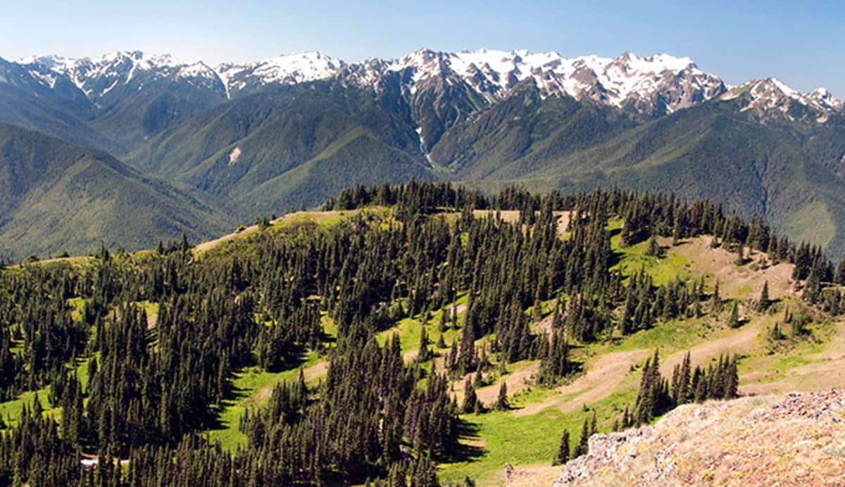
Hike#1: Hurricane Hill, Hurricane Ridge
|
Location of the Trail Head |
Hurricane Ridge Vision Center |
|
Elevation Gain |
240 m |
|
Hike Duration |
1 to 2 hours |
|
Level of Difficulty |
Simple to Moderate |
If you want a spectacular look of the horizon, the Hurricane Hill hike can be a good option. The view from the Hurricane Hill Vision Center is awe-inspiring. The overall hike is 1.6 miles long and comprises a variety of spots where you can rest and enjoy the breathtaking views around you.
The Hurricane Hill hike also provides you with panoramic views of the Strait of Juan de Fuca, snow-capped peaks of the soaring Olympic Mountains, and the peninsula. It is also the starting point of several long hikes such as a 22 km hike from the Elwha River Valley trail.
The route is typically clear and snow-free from July to September. As you continue to hike, you’ll come across thick pine forests, numerous helpful signboards and indigenous shrubs. Moreover, if you’re planning the hike during the summers, you may encounter deer, marmots and mountain goats.
Hike#2: Hoh River Trail

|
Location of the Trail Head |
Hoh Rain Forest |
|
Elevation Gain |
1558 m |
|
Hike Duration |
Approximately 3 days |
|
Level of Difficulty |
Simple to Moderate |
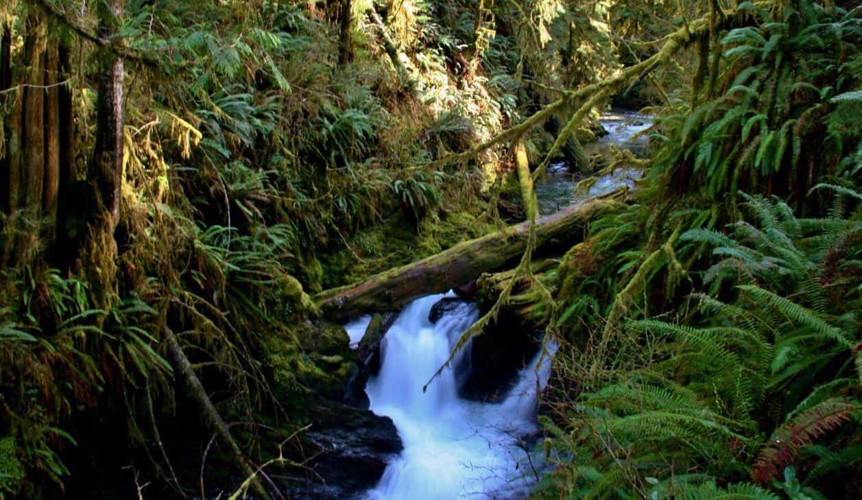
The Hoh River Trail is a top-rated trail in the Olympic National Park. The trail is located in the southwest region and receives around 12 feet rainfall every year. You’ll encounter heavy rainfall between October and April.
Throughout the trail, you’ll come across a plethora of ferns, mosses and unique shades of green. Western hemlocks and giant Sitka spruce enhance the exquisite environment. The hike begins as a relatively flat route along the north bank of the Hoh River and gradually transforms into a steep route until you reach the glacial meadow situated at the base of the Olympic Mountain.
However, it’s important to note that the Hoh River Trail is not only a day hike and comprises overnight adventures too. As you go deeper into the night, the hike continues and the trail gains elevation before reaching the Blue Glacier of Mount Olympus.
Right next to the Hoh River Trail are the starting points of two hiking trails suitable for families – Hall of Mosses and Sitka Nature Trail. Both hikes are a mile long and traverse through beautiful landscapes. Make sure you carry waterproof gear such as a backpack cover, a dry cover, rain jackets, socks, raincoat, and so on.
Hike#3: Mount Storm King
|
Location of the Trail Head |
Lake Crescent |
|
Elevation Gain |
519 m |
|
Hike Duration |
3 to 5 hours |
|
Level of Difficulty |
Somewhat difficult |
If you’re planning a hike for ‘stunning views’ only, the Mount Storm King hike will be a perfect choice. The lovely views of Lake Crescent are magical. The path travels via an ancient forest, facing two lookouts en route.
The first lookout is a cleared forest from where you can capture spectacular views of Lake Crescent and beyond. You can even see the faraway Straits of Juan De Fuca. To access the other lookout, you need ropeways to reach Mount Storm King’s summit.
Hike#4: Klahhane Ridge Trail and Sunrise Point

|
Location of the Trail Head |
Hurricane Ridge Visitor Center |
|
Elevation Gain |
518 m |
|
Hike Duration |
Approximately 3 hours |
|
Level of Difficulty |
Simple to moderate |
The Klahhane Ridge Trail starts with the Hill Ridge Trail which begins at the parking lot and ends at the junction with the Sunrise Trail Point. Simply follow this route to the Sunset Point for mind-blowing views of the Strait of Juan de Fuca. Alternately, you can continue hiking along the Hill Ridge Trail onto the Klahhane Ridge Trail.
Hike through fragrant flowery meadows crowded with marmots and deer. From here, you can also get scenic views of the North Cascades and Olympic peaks.
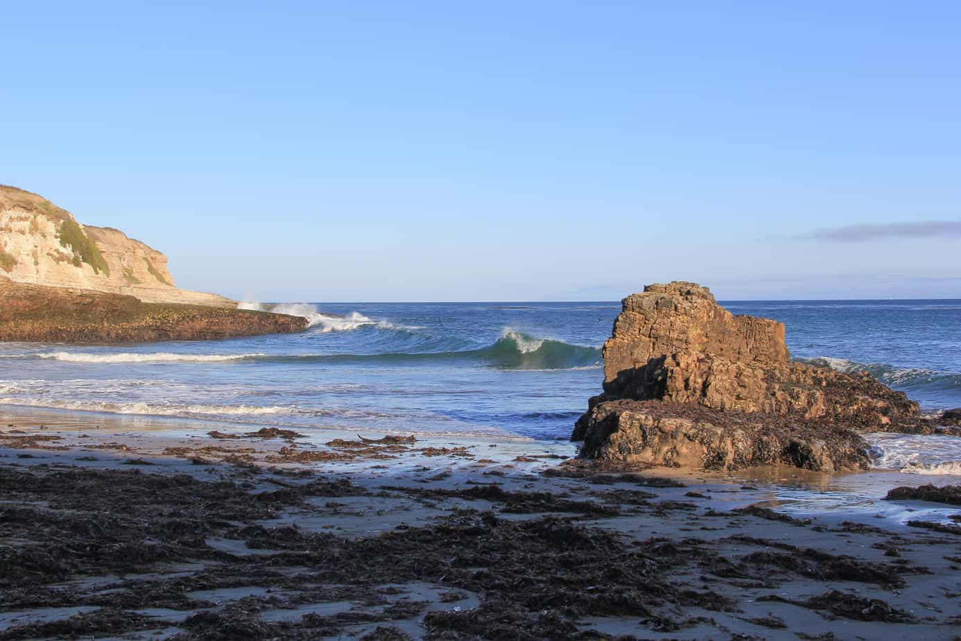
Hike#5: Rialto Beach

|
Location of the Trail Head |
Mora Road, La Push |
|
Elevation Gain |
Not applicable |
|
Hike Duration |
Approximately 1 hour |
|
Level of Difficulty |
Easy |
If you’re a fan of coastal walks, the Rialto Beach hike is all you need to lift your spirits. You’ll feel the freshness of the sea surrounding you from every corner. You’ll also encounter tiny tidal pools, large driftwood logs, beautiful seabirds. You can walk for as long as you want and sit by the waves when you’re tired.
Once you see the hole-in-the-wall rock, you can walk back as you cannot stay overnight, even if you have a permit. On your way back, you can explore the First Beach. You can also enjoy other similar walks such as Beach 4, Ruby Beach, Second Beach, and Third Beach.
Hike#6: Quinault Rain Forest Nature Loop
|
Location of the Trail Head |
Quinault National Forest |
|
Elevation Gain |
12 m |
|
Hike Duration |
Approximately 10 minutes |
|
Level of Difficulty |
Easy |
If you want to get a first-hand experience of the rainforests of the Olympic National Park, the Quinault Rain Forest Nature Loop can be a good start. The trail will provide you with unlimited access to the moss-laden landscape. This hike is more of a quick excursion than an elaborate hiking adventure.
The hike begins near Quinault Ranger Station and Lake Quinault’s shore, and starts from the parking area. As soon as you start moving along the trail, you’ll come across interpretive sign boards and sky-high trees. The signs inform hikers about the rainforest. As you walk over layers of slippery moss, through the gigantic trees, your ears will get filled with the sounds of birds and insects clicking and chirping.
The hike continues for approximately half a mile on a gravel-strewn trail, following the Wallaby Creek. If you take a minor turn and walk down a narrow trail as you move toward the parking area, you can catch a glimpse of a small waterfall.
Hike#7: Enchanted Valley Through the East Fork Quinault River
|
Location of the Trail Head |
Graves Creek Trailhead |
|
Elevation Gain |
518 m |
|
Hike Duration |
Approximately 2 days |
|
Level of Difficulty |
Moderate |
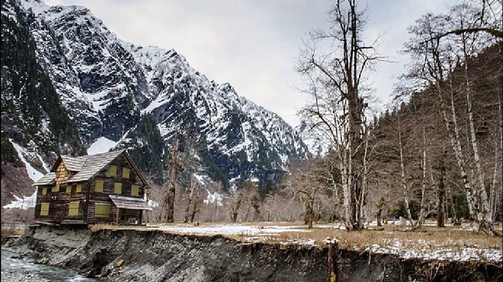
The Enchanted Valley chalet has been a resting spot for tired hikers and travelers since the 1930s. It was transformed into an Aircraft Warning Station during World War II and is now listed on the National Register of Historic Places.
To reach the Enchanted Valley, you’ll have to hike through old Douglas fir, Sitka spruce forests, and vibrant western red cedars alongside the East Fork Quinault River Trail. If you’re lucky, you may also be able to see the snow-covered Olympic Mountain range.
As soon as you reach the chalet, you can see the majestic mountains standing tall like the guardians of the valley. If you’re hiking during the summers, you can also see pristine waterfalls. However, make sure you stay alert as you hike, especially if you’re planning a camping adventure. The Enchanted Valley Trail is a ‘bear territory.
Hike#8: From Third Beach to the Strawberry Beach
|
Location of the Trail Head |
Third Beach Trailhead |
|
Elevation Gain |
99 m |
|
Hike Duration |
Approximately 8 hours |
|
Level of Difficulty |
Easy to moderate |
If you’re looking for a long beach trail unlike the Rialto Beach Trail, there is a chance you’ll like the hike from Third Beach to the Strawberry Beach.
As you walk along the shore, you’ll encounter colorful starfish, tide pools, spectacular sea views, and a lot more. Not only this but you’ll also walk through an exquisite ancient forest, into a ravine that leads to the campsite at the Third Beach. Even though most hikers prefer camping at the Third Beach, we recommend continuing your hike to the Strawberry Beach and camping there. However, make sure you keep track of the tides if you’re planning an overnight stay.
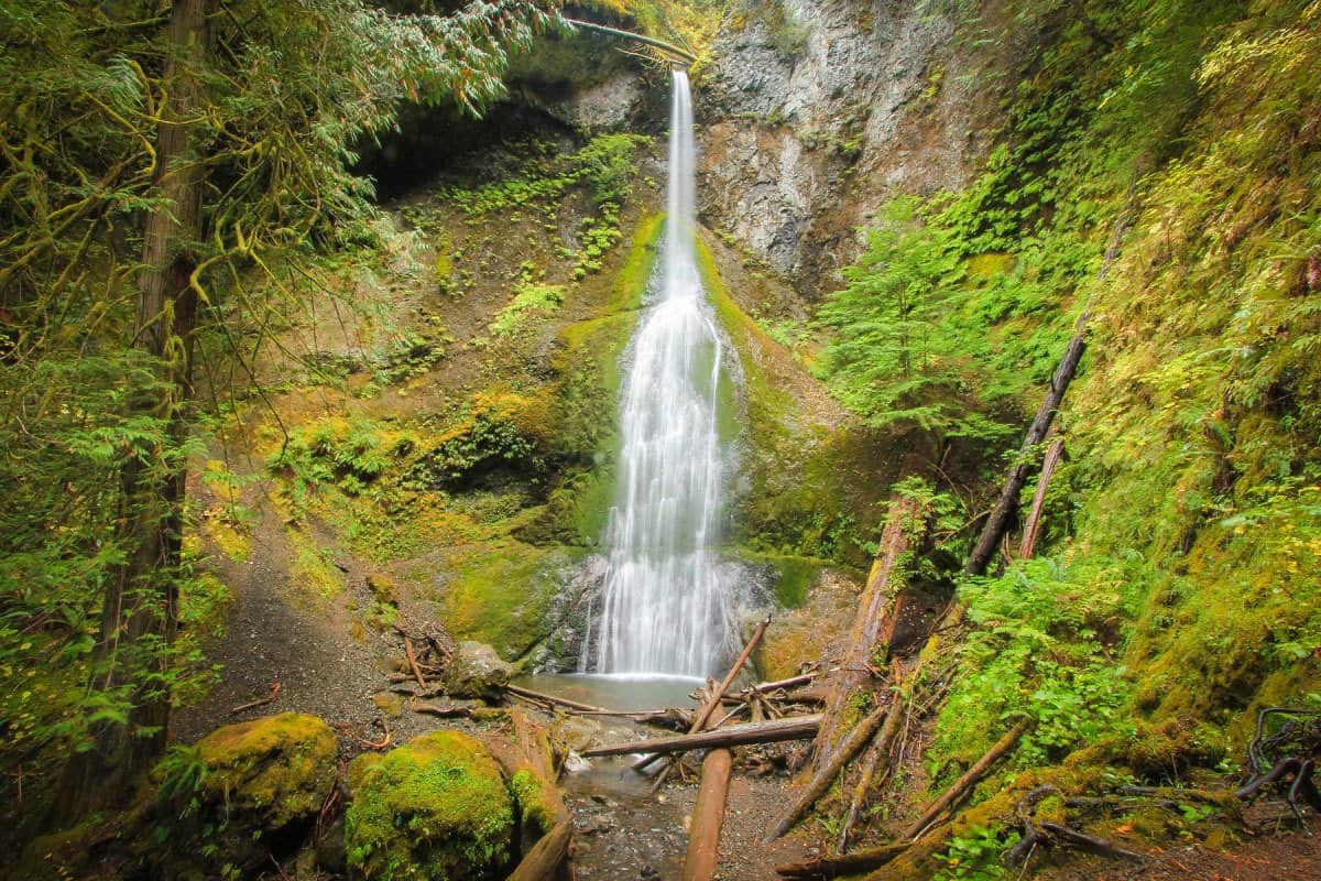
Hike#9: Marymere Falls
|
Location of the Trail Head |
Strom King Ranger Station, Lake Crescent |
|
Elevation Gain |
54 m |
|
Hike Duration |
Approximately 1 hour |
|
Level of Difficulty |
Easy |
You can easily access the Marymere Falls from Highway 101 through a narrow dirt path that passes through the dense forests of alder, cedar, hemlocks, and fir.
The Marymere Falls is popular picnic spot, with tourists flocking in and around the falls now and then. The source of the waterfall is a creek in Aurora Ridge. The hike to the Marymere Falls crosses numerous rivulets and bridges, followed by a quick walk uphill which is easy and comfortable for people of different ages. The picturesque view of the falls teamed with the gushing of the creek makes the Marymere Falls hike worth your efforts and time.
Hike#10: Ozette Triangle

|
Location of the Trail Head |
Lake Ozette |
|
Elevation Gain |
30 m |
|
Hike Duration |
Approximately 2 days |
|
Level of Difficulty |
Easy |
If you’re looking for a truly adventurous experience hiking through the beach shorelines and wandering through thick forests, you cannot afford to miss the Ozette Triangle hike.
The hike begins along the shoreline of the massive, natural lake in Washington – Lake Ozette. After crossing the crumbling bridge over the Ozette River, keep walking toward the right of the trail junction to continue the hike. From this point, the hike is simple and straight.
Are you wondering why the hike is called Ozette Triangle? Well, the trail is planned in a way that it comprises 3 straight routes: North Sand Point Trail, Cape Alava Trail, and the coastline that links the opposite sides. You can finish the hike in 2 days or stretch it to 3 depending upon your convenience.
Final Thoughts
Covering almost 1 million acres, the Olympic National Park is home to a variety of ecosystems that are rich in flora and fauna. Wild rivers gushing through the valleys, magnificent views of snow-capped peaks, lush green forests filled with the chirping of birds, waves crashing into the shoreline, stunning sunsets along the horizon, and so on; you can never get enough of the best hikes in Olympic National Park.
We bet you’ll be amazed by the diversity of flora and fauna found in Olympic National Park. There’s no dearth of opportunities to explore the unending wilderness that will leave you eager to spend more and more time in the park. Don’t get tired too soon. Stay motivated and keep going. Read our hiking quotes for further motivation.
We hope you found our guide to the best hikes in Olympic National Park worth reading. If you feel we’ve missed or skipped any important information about the hikes mentioned above, please feel free to write to us. Also, if there are any more hidden gems in the Olympic National Park that we are unaware of, we would love to hear from you.

Jodie Chiffey loves the outdoors. If you aren’t sure where to find her, check the nearest dirt trail. She loves being outdoors and spends a good deal of time reviewing products like clothing, footwear, and other outdoor gear.
Jodie is a full-time blogger who reviews a lot of the products for us. She writes many of our backpacking gear reviews, outdoor skills advice, and information, and helps visitors find the best destinations for backpacking, camping, hiking, and a lot more.
If Jodie’s friends have a travel or outdoors question, they know who to ask and that’s why we featured on our website. Now you can get the same great advice her friends enjoy, so you know where to go and what gear to take with you.